I saw aterrific blog post today about the Mount St. Helens eruption, which happened 35 years ago today. Remembering Mount Saint Helens 1980 (via Erik Klemetti @eruptionsblog on Twitter).
I was in Portland that day (at my parents' place, a couple of weeks after my junior year at Reed), and I saw the volcanic plume that afternoon. The eruption was on a Sunday morning at about 8:30, but it did not become visible until mid afternoon when the overcast cleared. I couldn't see the mountain itself (the West Hills blocked our view) but we could see the volcanic plume--the eruption continued all day long. Very impressive from 60 miles away: it looked like a big grey thunderhead. I wanted to get a better view of the mountain, but instead, we watched the live coverage on the local TV stations. This was incredible, showing the lahar (mud and debris flow) as it devastated the Toutle River valley in southwest Washington state.
There were subsequent eruptions that summer, two or three of which I got a better view (of the mountain itself as well as the plume). I was in Portland for one of the ash falls that happened in Portland itself--a fine heavy grit that covered everything. (I was out of state for the heaviest such ash fall; when I returned later in the summer, ash was still easy to find in places where it had accumulated.) Folks who come by my office at school can see a peanut butter jar filled with ash; this was kindly given to me by my colleague Chris Bjornson.
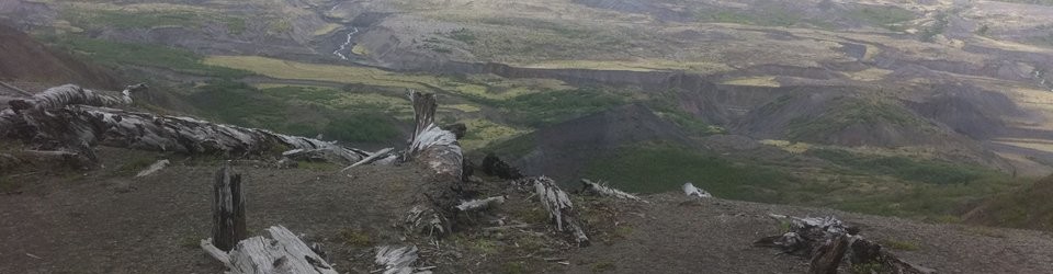
It occurs to me to mention that the banner image on this blog shows logs remaining from the eruption, at the Johnson Observatory [see below]. I took that picture a couple of years ago on a visit to the volcano with some old friends. I remember seeing the zone of destruction, which was more than 200 square miles, a year after the eruption. I went with family members, including my grandfather. This was astounding: we drove through a forest, and suddenly, we were in the zone of destruction, which had a sharp edge marking where the pyroclastic flow from the mountain had gone. The zone was vast (roughly 15 miles across). It's now beginning to recover and turn green.
Banner image mentioned above: